
Ich ziehe für eine Nacht innerhalb von Swanage um, denn hier ist aufgrund von militärischem Sperrgebiet nur noch eine Etappe zu laufen. Zum Glück kann ich mein Gepäck vorher abgeben. Leider sind meine Mails zur Gepäckaufbewahrung bis auf eine unbeantwortet geblieben. Die war höflich, aber wenig hilfreich. Werde die Tage mal in Portland auf dem Campingplatz persönlich vorsprechen, vielleicht hilft das.
Ich starte um 10:20 Uhr in Kingston und als ich das Meer erreiche, bin ich gerührt. Ich sage es immer wieder: Nirgendwo ist es so schön wie hier. Ich sehe aber auch auf den ersten Blick, dass das heute kein Kinderspiel wird.

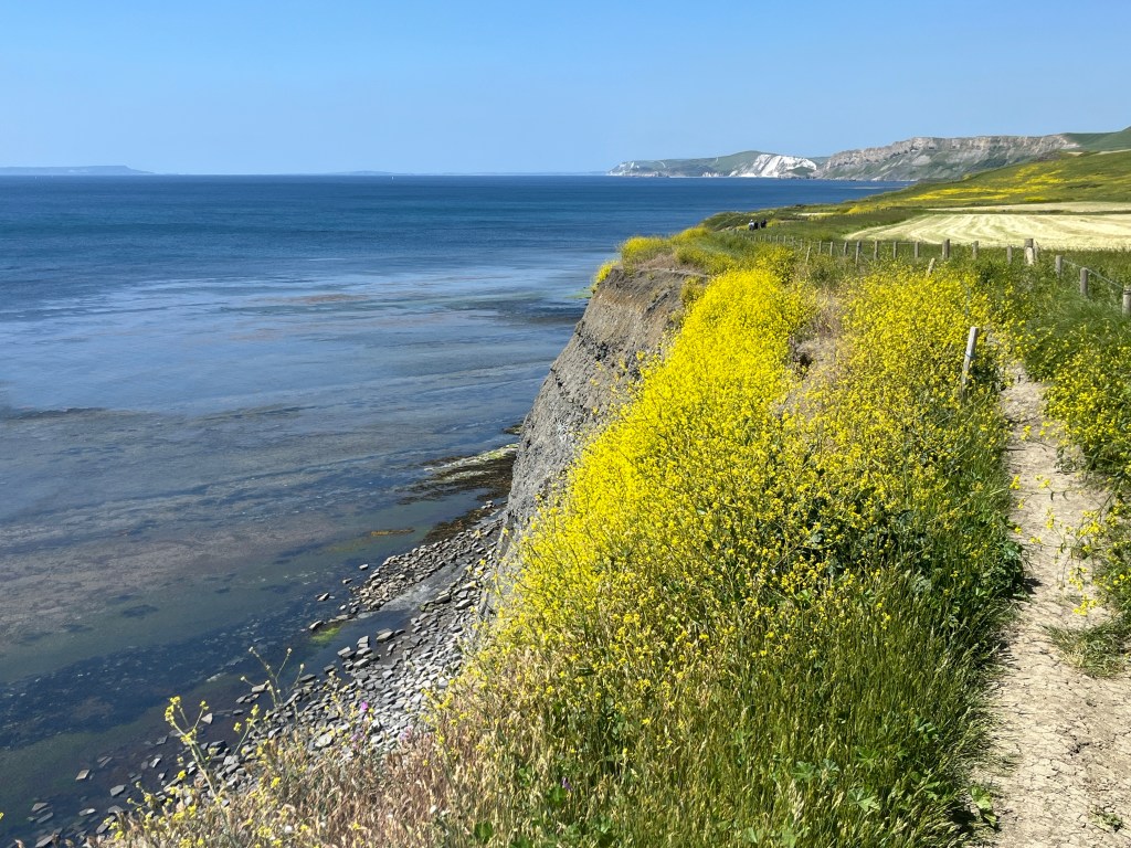
Heute ist es deutlich wärmer, in Shorts kann man trotzdem nicht gehen. Links, das sind Brennesseln.

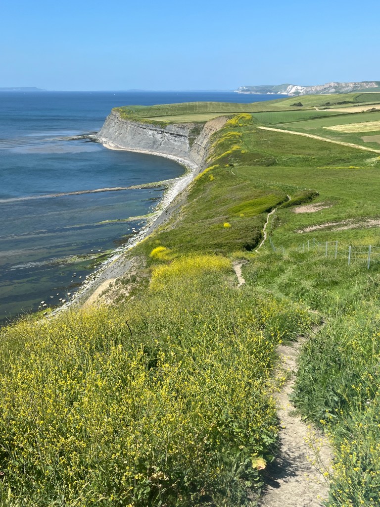
Der erste Abstieg ist so steil, dass ich überlege, ihn rückwärts auf allen Vieren zu gehen. Ich weiß nicht, wie lange es hier nicht geregnet hat, aber die Erde ist furztrocken und damit brüchig und rutschig. Ich geh trotzdem vorwärts, dauert aber.
Dann beginnt die Rapsschlacht. Auf den Fotos schön, für den Wanderer eher geschwindigkeitshemmend. Wir reden über „Manns-Höhe“. Das in der Mitte ist mein Pfad.
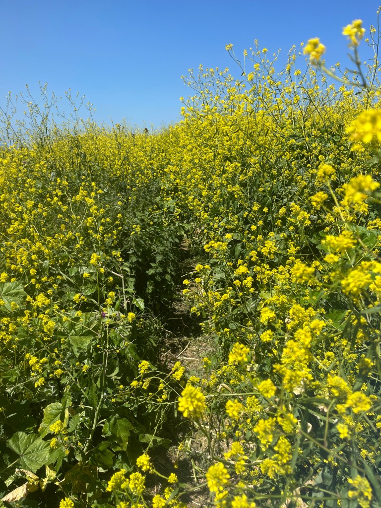
Hier darf man keine Berühungsängste mit Tier und Pflanze haben. Von diesen Abschnitten „im Vollkontakt durch den Raps“ gibt es heute mehrere. Wie man anschließend aussieht? Hälfte gelber Blütenstaub, Hälfte Rapskäfer. Und zwar überall.


Echt fertig in Kimmeridge angekommen, gönne ich mir ein Eis und sehe, dass da noch massig Steigungen auf dem Inlandsweg zurück zur Bushaltestelle liegen.

Als ich einen Moment Netz habe, sehe ich, dass es bis Kingston noch 5 Meilen sind! Leute, 5 Meilen!!! Inzwischen sind gefühlte 30 Grad, im Inland weht kein Wind, ich bin seit 4,5 Stunden unterwegs und fertig. Ich beschließe, ein Taxi zu rufen, denn Busse fahren hier nicht. Das Netz kommt aber nicht wieder. Ich muss also zurück nach Kimmeridge und dort im Hotel fragen. Taxi kommt, muss natürlich außen rum fahren und kann nicht den Feldweg nehmen. 20 Pfund weg. Ach nein, wir wollten ja nicht mehr über Geld sprechen.
Egal, mit jeder Minute im Taxi weiß ich, dass ich die richtige Entscheidung getroffen habe. Zurück in Swanage gucke ich mir die Komoot-Tour an und verstehe es nicht: 11 Kilometer gehe ich mit. 250 Höhenmeter zweifel ich an. Das gestern sollen 300 gewesen sein, da stimmt was nicht. Laufzeit 2:45. Niemals. Mindestens 4,5. Ja… für 11 Kilometer. Willkommen auf dem South West Coast Path!
Den Grund für das Zahlendurcheinander finden wir noch raus. Jetzt Essen, Duschen, Bett. Und Fakt ist auch, mit vollem Rucksack hätte ich das niemals geschafft. Ich muss das Zeltzeug loswerden.
Fundstück des Tages:

Tag: 11 km / 250 HM, kum 43 km / 690 HM
********************
The Rape Battle (Kingston to Kimmeridge)
I am moving within Swanage for one night as there is only one more leg to run here due to a restricted military area. Luckily I can drop off my luggage beforehand. Unfortunately, all but one of my emails regarding luggage storage have gone unanswered. She was polite but unhelpful. I’ll call in person at the campsite in Portland one of these days, maybe that will help.
I leave Kingston at 10:20 am and when I reach the sea I am touched. I say it again and again: Nowhere is it as beautiful as here. But I can also see at first glance that it won’t be child’s play today.
It’s much warmer today, but you still can’t go in shorts. Links, these are stinging nettles.
The first descent is so steep that I consider walking it backwards on all fours. I don’t know how long it hasn’t rained here, but the earth is dry and therefore brittle and slippery. I’m going forward anyway, but it takes time.
Then the rap battle begins. Beautiful in the photos, rather slow-moving for the hiker. We’re talking about „man’s height“. That in the middle is my path.
Here you must not be afraid of contact with animals and plants. There are several of these sections „in full contact through the rape“ today. How do you look afterwards? Half yellow pollen, half colza beetle. And everywhere.
Arrived in Kimmeridge really exhausted, I treat myself to an ice cream and see that there are still a lot of climbs on the inland route back to the bus stop.
When I have a moment of network, I see it’s 5 miles to Kingston! Guys, 5 miles!!! In the meantime it feels like 30 degrees, there is no wind blowing inland, I’ve been on the road for 4.5 hours and that’s it. I decide to hail a taxi because there are no buses here. But the network doesn’t come back. So I have to go back to Kimmeridge and ask at the hotel there. Taxi comes, of course, has to drive around the outside and cannot take the dirt road. 20 pounds off. Oh no, we didn’t want to talk about money anymore.
Regardless, with every minute in the cab I know I made the right decision. Back in Swanage, I look at the Komoot tour and don’t understand it: I’m going 11 kilometers. I doubt 250 meters of altitude. It was supposed to be 300 yesterday, something is wrong. Running time 2:45. Never. At least 4.5. Yes… for 11 kilometers. Welcome to the South West Coast Path!
We’re still finding out the reason for the jumble of numbers. Now eat, shower, bed. And it’s also a fact that I would never have made it with a full backpack. I have to get rid of the tent stuff.

Interessant. Wir laufen ja mit Outdooractive und im Vergleich zu unserem neuen Garmin gab es im letzten Radurlaub auch erhebliche Abweichungen, was die Höhenmeter betrifft. Bei Garmin waren sie dann nach der Tour teilweise doppelt so hoch! Verstehen wir auch nicht .. Schon lustig mit den Rapsfeldern – wenn man nicht selber drin steht! 😉
LikeLike